Bette Smith>Mildred Cameron>Stella Knox>Wm Wallace Knox>Margaret Anderson>Ann Graves (my third great grandmother)
When I think of Ann Graves Anderson, I imagine her as a hardworking farm wife in rural Clarence Township, Russell County, Ontario. She lived in an area of bad roads, few neighbours, and even fewer amenities. In the 1860s, she and her husband, along with daughter Margaret and son-in-law John Knox and their children, lived in a one-story timber-framed house while some of her neighbours were still living in log houses.[i] When we began our family research, we knew little about Ann except that she was born in 1813 in New York but at some point moved back to Canada. Family lore has it that she met her future husband, George Anderson, at the Montreal home of a United Empire Loyalist family.
Further research has shown that Ann came from a distinctly urban background. In fact, Ann was a big-city girl. Her father, Richard, was a Master Blacksmith who initially worked in Montreal. By 1809, he and his wife Juliann had moved their young family to New York City which in 1810 had a population of 72,000 within a land area of 1.5 square miles.[ii] When Ann was born in 1813, the Graves were living at 92 Mulberry Street, Ward Six, Lower Manhattan. Richard purchased the lot in 1815 for US $1,100[iii] and the property was described in the land books as being the third lot from the corner of Mulberry and Pump streets[iv].
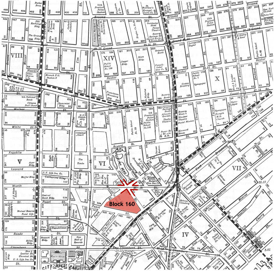
The above map was produced as a teaching aid for the American Social History Project/Center for Media and Learning. [v] Block 160 was the site of a 1991 archaeological excavation which sifted through the food remains left by the first residents (mostly middle class artisans like Richard Graves, as well as free and native-born blacks), and the very poor mid-century immigrants—Irish, Germans, Polish Jews, Italians and some from China.[vi] Mulberry at Pump (now Canal) on this map is a few blocks north of Block 160, very close to what would later become the infamous “Five Points”.
Pre-existing the American Revolution, Mulberry Street had once been nicknamed Slaughter Street. At that time, it was located beyond the city limits and was home to a number of slaughter houses. By the late 1790s, the abattoirs had been forced to move further into the countryside. Unfortunately, this area was very close to what was once Collect Pond which by the early 1800s had become a communal open sewer. The City wanted to develop the area for housing in order to keep pace with the growing population. They decided to drain the pond by building a forty-foot by eight-foot ditch (today’s Canal Street) and fill in the pond with waste soil.
By 1811, the City had completed the filling of Collect Pond. A neighborhood known as Paradise Square soon arose over the pond’s previous site. Unfortunately, due to the area’s extremely high water table, Paradise Square began to sink in the 1820’s. The neighborhood also began to emit a foul odor, prompting the most affluent residents to leave the community. By the 1830s, Paradise Square had become the notorious “Five Points,” an extremely poor and dangerous neighborhood renowned for its crime and filth.[vii]
After the drainage work was completed in 1811 the area was developed and became very attractive to middle-class buyers. When the Graves family arrived in New York City, “Slaughter Street” had become “Mulberry Street” because of the many Mulberry trees in the neighbourhood. The area was the home of tradesmen, merchants and professionals, although this lasted for only a decade.[viii] By 1813 the pond was no longer visible, but the land had not been allowed to settle before the houses were built. The ground below and the land surrounding the former pond remained marshy. The newly built houses almost immediately began to sink and decay.
“An 1811 lithograph[ix] shows the drainage canal as it passes under a bridge at Broadway. Canal Street runs on both sides of the water.”[x]

When the stench and unhealthy living conditions caused by the marshy ground took hold, most affluent residents left. The poorer African Americans who had been in the area since before the American Revolution remained and were joined by waves of immigrants from around the world.
The teaching aids published by the American Social History Project on “Five Points” focus primarily on the Irish immigrants who arrived as a result of the Irish Potato famine (1845). They were destitute when they arrived in the United States and their poverty forced them to live in Ward Six. By the 1830s this area had already become a slum, filled with crowded tenements, disease and violence. Protestant leaders of New York City condemned the Irish Roman Catholics for being the stereotypical drunk, indolent, quarrelsome criminals who were unwilling to adopt American values. Some went so far as to recommend that the children of these immigrants be removed forcibly and sent to upstate [read Protestant] homes and farms. Sounds a bit like the Canadian decision to send indigenous children to residential schools, doesn’t it? The immigrants had few options for a better life, limited as they were to the work of unskilled labourers. In 1841, Charles Dickens, who was making a tour of America, insisted on visiting “Five Points” and had this to say:
Ascend these pitch-dark stairs, heedful of a false footing on the trembling boards, and grope your way with me into this wolfish den, where neither ray of light nor breath of air, appears to come…
Here too are lanes and alleys, paved with mud knee-deep, underground chambers, where they dance and game; the walls bedecked with rough designs of ships, and forts, and flags, and American eagles out of number: ruined houses, open to the street, whence, through wide gaps in the walls, other ruins loom upon the eye, as though the world of vice and misery had nothing else to show: hideous tenements which take their name from robbery and murder: all that is loathsome, drooping, and decayed is here.[xi]
Charles Dickens, American Notes for Circulation in Two Volumes, Vol. 1 (London: Chapman and Hall, 1842)
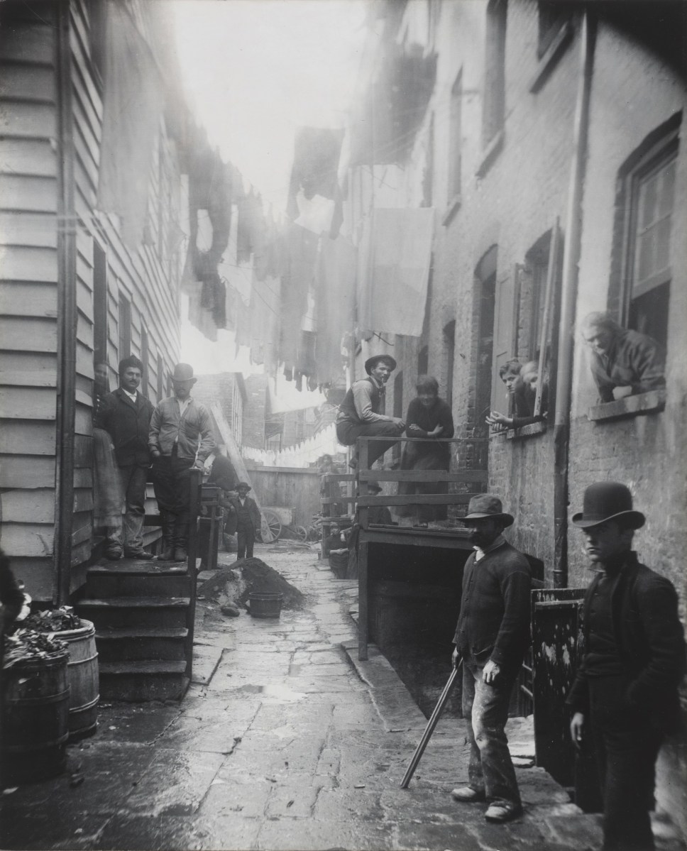
By mid-century, the name “Paradise Square” could only be used ironically. The “Five Points” story does eventually get better, but not until Jacob A. Riis, himself an immigrant from Denmark, published his 1890 book How the Other Half Lives.[xii] He used innovative flash photography to document life in the Lower East Side which at that time was the most densely populated place on earth. He formed a relationship with then Police Commissioner Theodore Roosevelt who implemented some of Riis’s social reform ideas when he became President. After the book was published, the authorities could no longer remain indifferent and social reforms began including the cleanup of tenements and elimination of poor houses run by the police.[xiii]
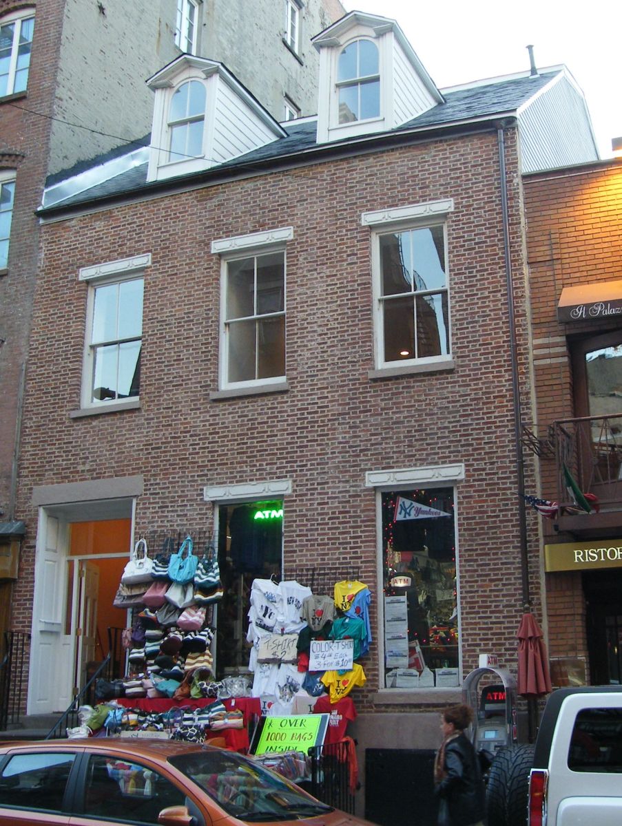
Only one of the many houses built in the early 1800s remains on Mulberry today. It is now a store with living quarters on the second story. The house was built in 1816 at 153 Mulberry by one of New York City’s richest businessmen and developers, Stephen Van Renssaelaer and was assessed at $3,750 shortly after it was built. It typified the type of modest single family homes that were being built during this time period in New York. It was moved to 149 Mulberry in 1841.[xvi]
The Guide to New York City Landmarks describes the building:
“149 Mulberry Street (c. 1816), designated as the Stephen Van Rensselaer House, 1969. This brick-faced, wood-frame house exemplifies the small row houses in the Federal style that were once common in Manhattan south of 14th Street. The Flemish bond brickwork, paneled stone lintels, gambrel roof, and dormer windows are characteristic of the style. The house was one of many in the area erected by Stephen Van Rensselaer; it was originally located on the northwest corner of Mulberry and Grand Streets, and was moved in 1841.” [xvii]
By the beginning of the 1800s, New York City was already becoming a city of diverse ethnicities. While Richard Graves was an Episcopalian of English background, his wife Juliann was French Roman Catholic. She ensured that their children were baptized in the Roman Catholic faith. We have not yet found the baptismal entries for two of their children, Richard Jr and Ann. However, it would be highly unlikely that Juliann would not have had them properly baptized. Four of their children—John Darling, Thomas, Juliann and Mariam (or Mary) were baptized at St. Peter’s which is the oldest Roman Catholic congregation in New York City, postdating the American Revolution by only two years.
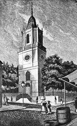
“As the congregation grew, they launched a plan to build a church of their own, under the leadership of Father Whelan. Fr. Whelan, a member of the Capuchin Order from Ireland, reported that the first pastor would need to know six languages spoken by the congregation of English, French, Dutch (i.e. German), Spanish, Portuguese and Irish.”[xix] Anti-Catholic prejudice was then widespread in New York City and the congregation was persuaded that it would be better if they located their new church outside the city limits. Land was made available to them by an Episcopalian congregation at what is now the corner of Barclay and Church Streets. The cornerstone for the new church was laid on October 5, 1785 and the first High Solemn Mass was said on November 4, 1786. (Saint) Elizabeth Ann Seton and (the Venerable) Pierre Toussaint were both devoted members of St. Peter’s during the years when the Graves’s children were baptized. It is also claimed that Billy the Kid (Henry McCarty) was baptised at St. Peter’s in 1859.[xx] The original church (shown below)[xxi] was replaced by the present building on the same site with the work completed by 1840. [xxii]
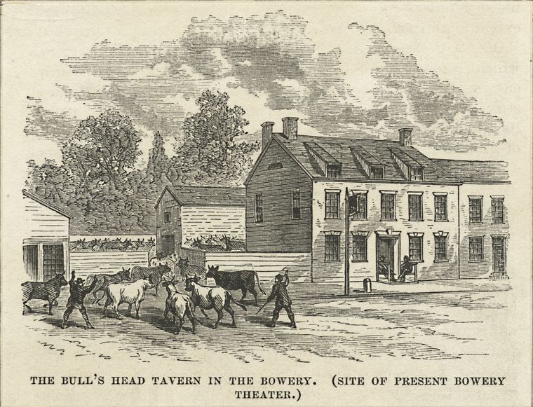
Another landmark in this area was the Bull’s Head Tavern. Initially it catered to the farmers and drovers who brought cattle and other livestock to the slaughter houses and was probably located at what is now 52-55 Bowery, three blocks over from Mulberry. When the British fled from New York City on November 25, 1783, “George Washington and his entourage met at the Bull’s Head, preparing themselves for their triumphant entry into town. Governor George Clinton and over 800 uniformed troops and town people gathered right outside, preparing for the procession.” [xxiii] The Bowery Boys History blog notes that the Bull’s Head survived at the Bowery location until the early 1820s when new owners moved it to 3rd Avenue and 24th Street. Richard may well have stopped by the Bull’s Head for a pint of beer and conversation with other tradesmen when the work of the day was done. The following picture depicts the Bull’s Head as it would have been in the eighteenth century.[xxiv]
By 1814, Richard Graves and other NYC blacksmiths were having financial difficulties. Along with 12 others, he advertised in the Evening Post that prices would be increased because of the “enormous price of iron, coals and labour”.[xxv] His brother William, also a blacksmith, joined him—likely following the end of the War of 1812 and the Treaty of Ghent which took effect February 1815. In October 1816, Richard sold his property to William for $500 although the purchase was not recorded until March 1, 1817 when William sold the same lot for $300 to Joseph J. Burtis (a loss of $800 over 2 years).[xxvi] By May 24, 1817, Richard filed for bankruptcy.[xxvii] Later documents suggest that Richard’s health was failing due to an unstated disease and that his ability to work was badly compromised. An 1819 New York Jury List[xxviii] showed that Richard was last living in Manhattan at 79 Bowery Street, just “north-east”[xxix] of Canal Street.
By August 1819, Richard, his wife Juliann and children had returned to Montreal. Ann was then just six years old.
[i] Library and Archives Canada, “1861 Census of Canada”, Enumeration District 1, Clarence Twp, Russell, p. 11, Lines 27-34, entry for George Anderson Household. Database with images, Ancestry.com (Source Library and Archives Canada [LAC], Ottawa, ON, Census Returns for 1861; Roll: C-1071: (https://www.ancestry.ca/imageviewer/collections/1570/images/4108337_00399?pId=792417214: accessed 06 Jun 2022).
[ii] Cox, Wendell, “New York Urbanized Area: Population & Density from 1800 (Provisional)”. (blog) Demographia, nd (demographia.com/db-nyuza1800.htm: accessed 18 May 2022).
[iii] New York Land Office, “United States, New York Land Records, 1630-1975”, New York, Conveyances 1815-1816, Vol. 110-112, Land Assessment, 28 Jul 1815, New York City, Entry 110, pp 403-404, Grantee, Richard Graves. Database with images Family Search (https://www.familysearch.org/ Images 102-103 of 759: accessed 5 Jun 2022).
[iv] Tauber, Gilbert, (blog) Old Streets, Letter P. (oldstreets.com/index.asp?letter=P: accessed 4 Jun 2022).
Pump Street was merged with Walker Street in 1829 and by 1855, it was part of Canal Street.
[v] American American Social History Project/Center for Media and Learning, “Map of New York City’s Sixth Ward and Surrounding Areas, 1899,” SHEC: Resources for Teachers. Source: “Section of lower Manhattan in 1899,” map from Jacob A. Riis, How the Other Half Lives, (New York: Dover Books, 1971), 230. Modified by the American Social History Project/Center for Media and Learning. (https://shec.ashp.cuny.edu/items/show/826: accessed 4 Jun 2022 and used with permission).
[vi] Hauck-Lawson, Annie and Deutsch, Jonathan, eds., “Digging for food in Early New York City”, Gastropolis: Food and New York City (NY: Columbia University Press, December 2008), ebook, p. 58.
[vii] “New York City Dept of Parks and Recreation, NYC Parks, “Collect Pond Park” (https://www.nycgovparks.org/parks/collect-pond-park/history: accessed 5 Jun 2022).
[viii] “A Mulberry Street house is a ‘lonely reminder’”, (blog) Ephemeral New York: Chronicling an ever-changing city through faded and forgotten artifacts, posted 18 Mar 2019 (https://ephemeralnewyork.wordpress.com/: accessed 18 May 2022).
[ix] “Bridge at Broadway and Canal Street, 1811” lithograph, original source: The Memorial History of the City of New York: From Its First Settlement to the Year 1892, vol 3, p. 204. Wikimedia Commons (https://upload.wikimedia.org/wikipedia/commons/0/05/New_York%2C_Bridge_at_Broadway_and_Canal_Street_1811.jpg: accessed 7 Jun 2022)
[x] “Collect Pond and the origins of Five Points”, (blog) Secondat, posted 2 Jun 2010, ((http://secondat.blogspot.com/2010/06/collect-pond-and-origins-of-five-points.html
[xi] Bowery Boys: New York City History, “Charles Dickens’ guide to New York City low life”, (blog) Bowery Boys History, Posted 21 Aug 2008 (https://www.boweryboyshistory.com/2008/08/charles-dickens-guide-to-new-york-city.html: accessed 7 Jun 2022).
[xii] “Riis, Jacob A., How the Other Half Lives: Studies Among the Tenements of New York (NY: Charles Scribner’s Sons, 1890) (https://www.gutenberg.org/files/45502/45502-h/45502-h.htm: accessed 8 Jun 2022).
[xiii] Jacob A. Riis Museum, Ribe, Denmark, “Jacob A. Riis Biography” (jacobariismuseum.dk/en/jacob-a-riis/: accessed 8 Jun 2022).
[xiv] Photograph of Jacob A. Riis, Wikimedia Commons (https://commons.wikimedia.org/wiki/File:Picture_of_Jacob_Riis.jpg: accessed 8 Jun 2022)
[xv] Riis, Jacob A., 1888 photograph “Bandits’ Roost, 59 1-2 Mulberry Street”, Wikimedia Commons (https://commons.wikimedia.org/wiki/File:Bandits%27_Roost,_59_1-2_Mulberry_Street_by_Jacob_August_Riis,_1888.jpg: accessed 8 Jun 2022).
[xvi]New York City Landmarks Preservation Commission, document “Stephen Van Rensselaer House” 11 Feb 1969, No. 3, LP-0565 (http://s-media.nyc.gov/agencies/lpc/lp/0563.pdf: accessed 19 May 2022).
[xvii] Andrew Dolkart/New York Landmarks Preservation Commission, Guide to New York City Landmarks (NY: John Wiley & Sons, 2008) p. 41 (http://s-media.nyc.gov: accessed 19 May 2022).
[xvii] Photo used with permission from the photographer, Americasroof, CC BY 3.0 (https://creativecommons.org/licenses/by/3.0, via Wikimedia Commons: accessed 4 Jun 2022).
[xix] St Peter’s Church│Our Lady of the Rosary, “St. Peter’s Church History” ( https://spcolr.org/st-peters-church-history: accessed 19 May 2022).
[xx] Hufford, Deborah, “Billy the Kid”, (blog) Notes from the Frontier, posted 4 Apr 2020. (https://www.notesfromthefrontier.com/post/billy-the-kid: accessed 7 Jun 2022)
[xxi] Image of Old St Peter’s Church, NYC; source “The Catholic Church in the United States of America: Undertaken to Celebrate the Golden Jubilee of his Holiness, Pope Pius X”, Vol. 3, 1914, p. 360 (https://books.google.com/books?id-KL4YAAAAYAAJ); Wikimedia Commons (https://commons.wikimedia.org/wiki/File:Old_Saint_Peter’s_Roman_Catholic_Church_Manhattan_New_York.jpg: accessed 6 Jun 2022).
[xxii] St Peter’s Church│Our Lady of the Rosary, “St. Peter’s Church History” (https://spcolr.org/st-peters-church-history: accessed 19 May 2022).
[xxiii] Bowery Boys: New York City History, “Remnants of the Bull’s Head Tavern: Could this be the greatest New York archaeological find of the year?” (blog) Bowery Boys History, Posted 16 Oct, 2013 (https://www.boweryboyshistory.com/2013/10/remnants-of-bulls-head-tavern-could.html: accessed 6 Jun 2022).
[xxiv] The Miriam and Ira D. Wallach Division of Art, Prints and Photographs: Print Collection, The New York Public Library. “The Bull’s Head Tavern in the Bowery” New York Public Library Digital Collections (from the New York Public Library https://digitalcollections.nypl.org/items/510d47da-239e-a3d9-e040-e00a18064a99 : accessed June 6, 2022).
[xxv] “Notice”, The Evening Post, New York, NY, 15 Nov 1814, Tue, p. 3, (http://www.newspapers.com: accessed 26 Apr 2020).
[xxvi] New York Land Office, “United States, New York Land Records, 1630-1975”, New York, Conveyances 1816-1817, Vol. 117-119, Land Assessment, 1 Mar 1817, New York City, Entry 229, pp 582-584, Grantee, William Graves and Entry 230, pp. 404-405, Grantee, Joseph J. Burtis.
[xxvii] “Insolvents, Advertising for the Benefit of the Act in this State”, The Evening Post, New York, NY, 3 May 1817, Sat, p. 4, “New York—before Richard [B]aker, Recorder….Richard D. Graves, May 24…” (http://www.newspapers.com: accessed 7 Jun 2022).
[xxviii] New York City Dept of Records and Information Services, “New York County Jury Census”, ID REC0055_01_08_15, Ward 10, Box 8, Vol. 15, 1819, Image 5/186 (https://nycma.lunaimaging.com/luna/servlet/media/book/showBook/NYCMA~10~10~15~1206205: accessed 7 Jun 2022). Richard’s neighbours on Bowery St were tradesmen, artisans, and merchants. Some occupations of his neighbours: butcher, sail maker, book store, shoe store, innkeeper, physician, cabinet maker, custom house officer, carpenter. Richard was listed as exempt from jury duty because he was an “alien”.
[xxix] Petzold, Charles, “How Far from True North are the Avenues of Manhattan” posted Jul 2005 in (old blog) Et Cetera (https://www.charlespetzold.com/etc/AvenuesOfManhattan/: accessed 5 Jun 2022). I became thoroughly confused trying to decide where all the mapped locations were in relation to each other. Which way was north? According to Charles Petzold the decision was made in 1811 to lay Manhattan city avenues and streets in a grid pattern aligned to the island itself and the plan was followed “relentlessly”. This means that the grid is not oriented according to the polar north. Petzold has estimated that Manhattan avenues deviate from true north by 29⁰.

This is a very professional piece of research, Bette. I am impressed. We’re looking forward to your next post.
Gordon
>
LikeLike